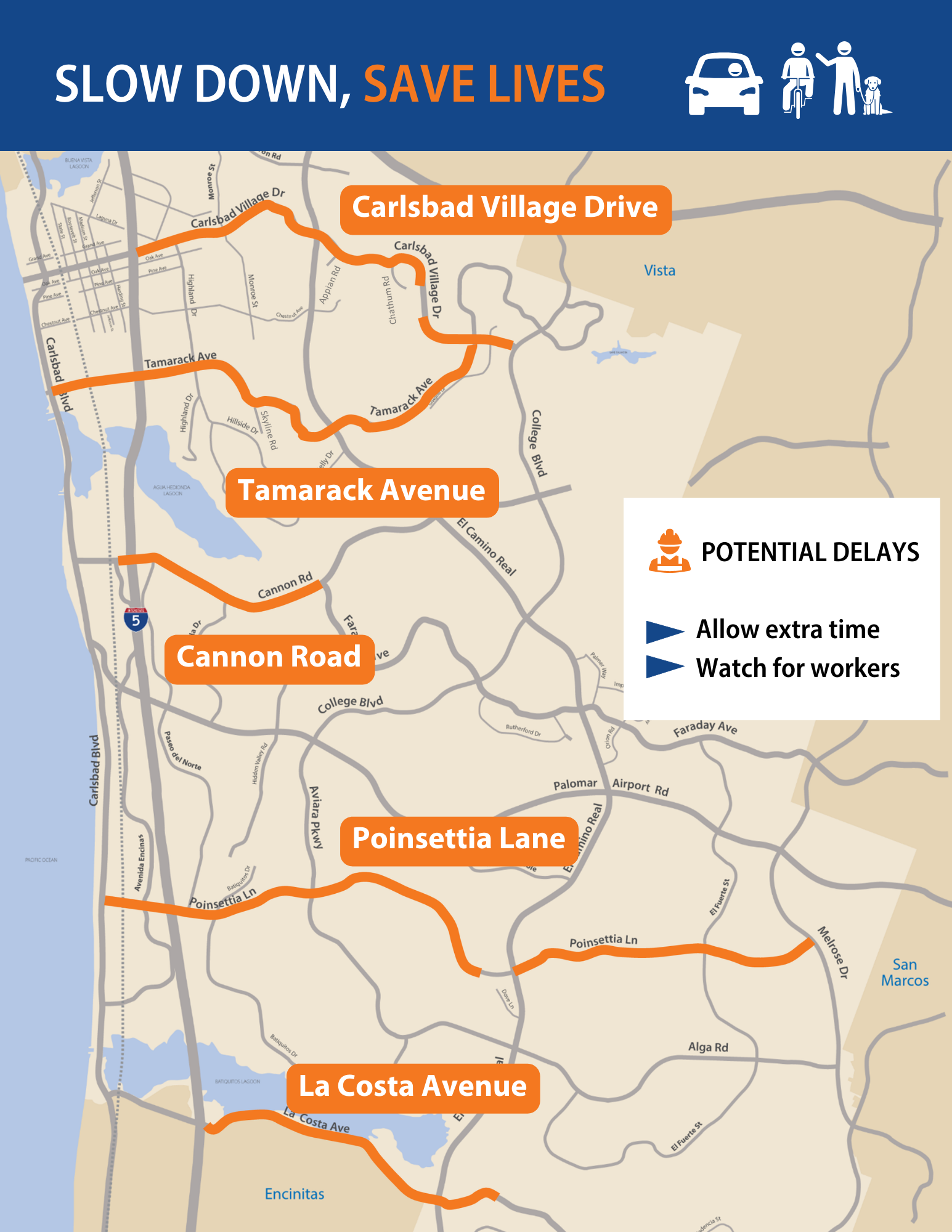
Road repaving and restriping continues this week on major east-west roadways in Carlsbad, as part of our overall efforts to encourage safer use of our streets.
Here’s what to expect
- Temporary lane closures, workers and detours along portions of Carlsbad Village Drive, Tamarack Avenue, Cannon Road and Poinsettia Lane.
- Street parking along Tamarack Avenue is temporarily unavailable, Monday to Friday, Oct. 9 to 13.
- Please leave early in anticipation of possible detours and give yourself plenty of time to get where you need to go.
- Slow down in construction zones and watch for workers and roadway sign directions.
Exactly where and when?
- Look for digital message boards and other signs indicating which portions of these streets are affected on which days.
- The paving and striping process requires crews to return to each location multiple times.
- We have planned this work to get it completed as quickly as possible and appreciate your patience.
Why this is important
- This work is one of dozens of projects approved or expedited by the City Council during our traffic safety emergency.
- Resurfacing takes care of cracks and potholes and lengthens its useful lifespan, saving money in the long run.
- Restriping the roads will reduce speeding while giving more space to walkers and cyclists. Unsafe speed is the leading cause of severe and fatal collisions in Carlsbad.
Areas getting resurfaced and restriped
In total, approximately 16 miles of major east-west streets throughout the city will be repaved and restriped.
- Carlsbad Village Drive (I-5 to College Boulevard), approximately 3.3 miles
- Reducing lanes between Appian Road to Chatham Road
- Tamarack Avenue (Carlsbad Boulevard to Carlsbad Village Drive), approximately 3.5 miles
- Reducing lanes between Skyline Drive to Carlsbad Village Drive
- Cannon Road (220 feet west of Avenida Encinas to Faraday Avenue), approximately 1.6 miles
- Poinsettia Lane (Carlsbad Boulevard to Melrose Drive), approximately 5.0 miles
- Reducing lanes between Carlsbad Boulevard and Avenida Encinas
- La Costa Avenue (I-5 to Fairway Lane, just past El Camino Real), approximately 2.3 miles
- Olivenhain Road (Encinitas city limits to Rancho Santa Fe Road intersection), approximately 0.2 miles

Other traffic calming features
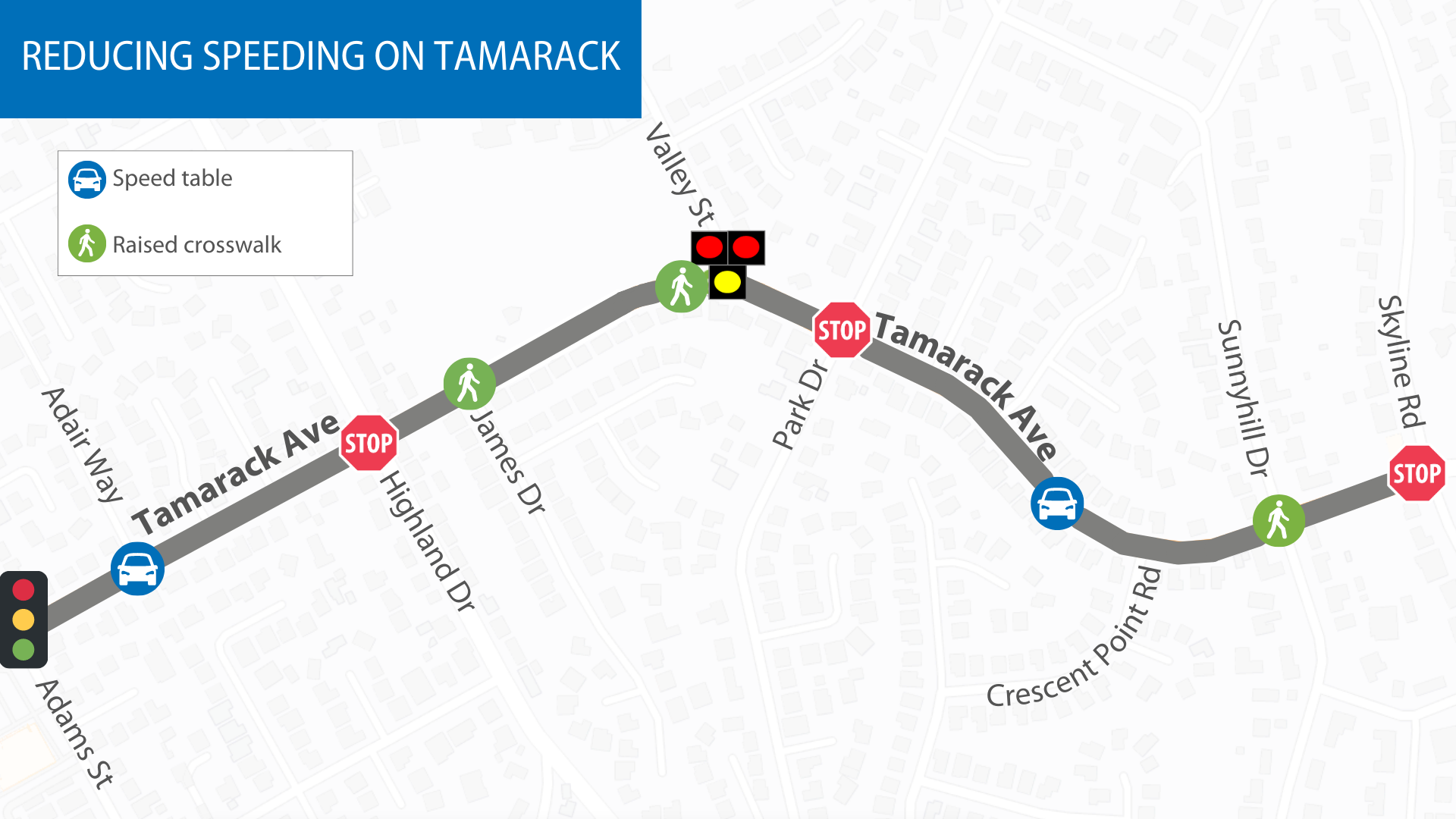
While driving on Tamarack Avenue, there are also new safety features between Skyline Road and Adams Street around the school.
- New flashing lights at the raised crosswalks have been installed, the last part of the short-term plan to reduce speeding in this specific area.
- A long-term redesign of the street is still planned for the future.
- The resurfacing and restriping of Tamarack Avenue will not impact the new safety features.
Speed tables
- Two “speed tables,” which look like extra wide speed bumps, are installed near Adair Way and west of Crescent Point Road.
- Speed tables have ramps on both sides, with a flat top that’s about the length of a car.
- The speed tables help signal drivers to slow down.
Raised crosswalks
- Raised crosswalks have been added at Sunnyhill Drive, Valley Street and James Drive.
- These help reduce speeds and make it easier for drivers to see pedestrians as they cross the street.
- Flashing lights have been installed at Sunnyhill and James, which alert drivers to watch for pedestrians or cyclists at the intersection.
- The raised crosswalk at Valley Street is paired with the previously installed hybrid signal, which stops traffic when a person presses the button to cross.
Here's where they are

More information
Repaving and restriping east west roadways
Slowing down in neighborhoods
Street design options
Designing for safety
Safer streets together
