This week city staff reported the outcome of a grant-funded project to show how critical infrastructure could be protected from future sea level rise.
The study covered the area around Carlsbad Boulevard between Manzano Drive and Island Way. Staff used modeling to show how over the next 96 years, the rising ocean will affect parts of the southbound lanes.
- Tuesday’s meeting focused on different approaches to moving the road out of harm’s way.
- These are called “adaptation strategies.”
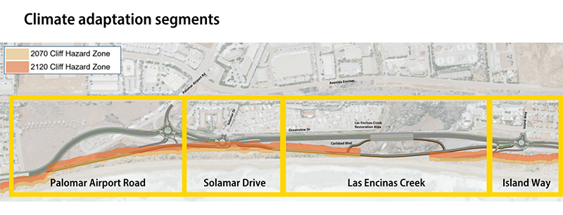
- Because different parts of the road would be affected at different times, the project team split the 1-mile stretch of road into four segments.
- The most vulnerable is the portion that dips down by Encinas Creek (just north of the little parking lot by Island Way).
- The city has already restriped the road in this area, turning the western most lane into a walking and biking area so that vehicle traffic is not affected when strong waves and storms bring water onto the road.

Sea level rise adaptation is still a relatively new discipline, so the city will need more data before further developing options. Staff plan to request funding in next year’s budget for the next set of studies.
Knowing that any work along the coastline will be expensive, the City Council asked staff to return with information about climate resilience districts. This is a tool cities can use to raise revenue, plan climate mitigation or adaptation projects, and implement those projects. Districts can be created to address sea level rise, extreme heat, extreme cold, and the risk of wildfire, drought and flooding.
You can read more about this topic in the staff report. If you want to stay updated with future milestones, sign up for email updates.
While we’re on the subject of roads, be sure to take a look at our construction map of current city projects so you know which areas will be affected and can change your route if needed. Keep in mind the map only shows city projects, not work being done by private companies or local utilities.
