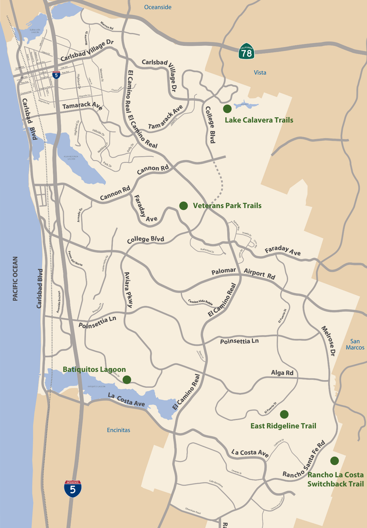
Have you been enjoying the extra hour of daylight since the time changed last week? If you're looking for outdoor activities to maximize those lighter evenings, here’s a roundup of just a few of the city trails that offer beautiful views (listed in order of the easiest hikes to the most challenging.)
Batiquitos Lagoon (South Carlsbad)
Length: 2.7 miles Difficulty: Easy
This trail is a pleasant hike in the shade of riparian trees, where hikers can enjoy vast views to the lagoon and observe wildlife including endangered birds such as the Snowy Plover, California Least Tern and Clapper Rail. The 561-acre lagoon owned by California Department of Fish and Wildlife and managed by The Batiquitos Lagoon Foundation is protected as a game sanctuary and bird estuary. Parking: Designated parking near the Visitor Center and on-street parking along Gabbiano Lane, parking lots on Batiquitos Drive at Pelican Street, across from Golden Star Lane and across from Spoonbill Lane.
Veterans Park Trails (North Carlsbad)
Length: 1.50 miles Difficulty: Difficult
The Crossings Golf Course trailhead is located at the parking lot of the golf course at the end of Crossings Drive. It is .6 miles to the underpass under Faraday Avenue and connects to the Veterans Memorial Park. This section of the trail goes through the golf course and crosses the Agua Hedionda Creek, which is a perennial stream that hosts a wetland community habitat. There are some steep sections along this trail so be prepared to get a little workout on the uphill sections. The Veterans Memorial Park trailhead off Faraday Ave is 1.5 miles and has steep elevations with grand views of Agua Hedionda Lagoon and the Pacific Ocean. Parking: Parking lot at The Crossings Golf Course or along Faraday Avenue near Veterans Park.
Rancho La Costa Switchback Trail
Length: 2.70 miles Difficulty: Difficult
The Rancho La Costa Trails are a collection of trails that are on or near the Preserve of Dank Mountain. Many of them are challenging with steep inclines and declines for the more intermediate to advanced hiker. The trails offer spectacular views of the Pacific Ocean and the San Marcos Mountains and on a clear day you can see downtown San Diego. The trailhead at the corner of Camino Junipero and Corte Romero is the start of the Switchback Trail. This is a great trail for those looking for a challenge or good workout. At the top of the mountain there is an over-head shelter with picnic tables with a spectacular panoramic view.
Please stay alert on this trail it is very popular with mountain bikers. If you are mountain biking, please be aware of others and travel at safe speeds while using this trail. Parking: along Corte Romero.
Lake Calavera Trails- Serpentine Trail (North Carlsbad)
Length: 2.6 miles (including the Lake Loop Trail) Difficulty: Difficult
The Lake Calavera Trails are a collection of 6.25 miles of trails throughout the Lake Calavera Preserve. The trails range from easy to difficult so there is something for everyone. Take the Lake Calavera Lake Loop Trail for a moderate hike around the lake. There are stunning lake views along the way and places to rest to take in the views. The Serpentine Trail connects to this trail on the north east side. It is pretty steep overall but has a lot of steady switchbacks that make for a manageable hike up and down the trail. It has great views at the top of the remnant volcano hilltop and out north towards Oceanside and the San Marcos Hills. This trail is extremely popular with mountain bikers and it is very important for both hikers and bikers to be on the lookout for each other, especially around corners and steep sections of the trail. Parking: on street on Tamarack Avenue.
East Ridgeline Trail (South Carlsbad)
Length: 2.10 miles Difficulty: Difficult
The trailhead starts at El Fuerte Street near Babilonia Street. There are great views of the San Marcos Mountains to the East and in the higher elevations of the trail, views to the Pacific Ocean. This trail comes close to the San Marcos Creek and Box Canyon area, but it is prohibited to access these areas for safety reasons. A seasonal creek within the drainage area of the open space corridor supports nesting habitat and protective cover from predators. This watershed connects to the Batiquitos Lagoon to the west, which supports unique avian fauna, flora and aquatic species specific to California coastal lagoons. Parking: On-street parking on El Fuerte Street.
For more information on all of Carlsbad's trails visit our GoHike Carlsbad portal to find all of our trail locations, points of interest, trail length, parking and more.
